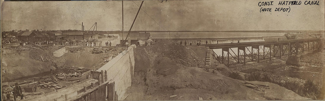
In 1904, a La Crosse Water Power Company dam was constructed just north of the Green Bay & Western tracks in Hatfield. This historical photograph captures both the dam construction and the west railroad bridge over the Black River with Lake Arbutus forming in the background.
On the west side of the photo, a flume to provide water to a downstream powerhouse is under construction. The arrow points to the Hatfield depot. This depot may go back to the original construction of the Green Bay & Lake Pepin Railroad in 1872. The depot was replaced with a new one in 1909, built further west and on the opposite side of the tracks, followed by a third depot in 1947.
Reports suggest the dam owners held an open house in July of 1904 to show area residents the dam and lake, allowing visitors to submit choices for naming the body of water.
An eastbound train begins crossing the Black River bridge at Hatfield. The Green Bay Route maintained a pair of bridges in Hatfield to span the Black River. The "west bridge" crossed the original river channel, while a second "east bridge" was added in 1904 when the river was dammed to form Lake Arbutus and generate hydroelectric power for the La Crosse Water Power Company.
Around the turn of the 20th century, an eastbound train led by a Green Bay Route 4-4-0 steam engine entered the west bridge with the west dam visible in the background.
On October 6, 1911, Hatfield was struck by a catastrophic flood that collapsed the east dam and washed out the east bridge. Stan Mailer's book Green Bay and Western details the severe disruption to regional railroad service caused by the severing of the line.
Postcard photograph taken by J.M. Colby (Wausau, WI), postmarked June 7, 1909 from Neillsville, WI. Special thanks to Scott Janz for sharing this historical image.